|
Local Links
David Bugli - Home Page
External Links
Carson
Valley Trails Association
Carson
City Weather Forecast
|
Hikes
Per Terry Sutor, back in June 2011: Here is the Monday schedule until the end of October 2011. (Many thanks
to those leaders who have come forward to fill in the blanks!) Please make
a copy and keep handy for I will not be sending out anymore weekend e-mails
unless there is a change to be made. I've listed the place, leader, meeting
location and time. Just show up on those outings which you'd like to
do. I haven't included any mileages because they will all be in the
3 to 5 mile range. Any questions, give the leader a call. (I also have
a camping schedule which you may obtain from me, if interested.)
Happy Hiking,
Terri
(Click here to return the main hiking page.)
- Leaders: Terri Sutor 267-5366 & Helen 882-6480
- Assistants:
- Dick Morissette - 267-3924
- Bob Verzello - 782-6990
- David Bugli - 883-4154
- Lisa - 783-0522
- Cathy - 530-541-5980
- Eileen - 267-2557
List of hike dates, hike areas, hike leaders, meeting locations, and meeting times
2011 Hikes
- June 6, 2011 - Rattlesnake Peak & Huffaker Hills / Reno / Terri / Old K-Mart on
College Parkway / Carson City / 9 A.M. -
map
- CANCELLED DUE TO RAIN
- June 13, 2011 - Jobs Peak Ranch Trail / Dick / Westwood Park ("Ironwood Park") / 9 A.M. -
info
- June 20, 2011 - Washoe Meadows State Park (in Meyers area, located 3.5 miles southeast
of South Lake Tahoe on U.S. 50) / Terri / Westwood Park ("Ironwood Park") / 8:30 A.M. (Note
change in meeting time -
was 9 A.M.) (Hikers can also meet at Burlington Coat Factory at 8:00 A.M. and meet the
rest of the hikers at Westwood
Park at 9 A.M.)-
info
- June 27, 2011 - Silver Saddle Ranch to Mexican Dam / David / Burlington Coat Factory
/ 9 A.M. -
info on Silver Saddle Ranch
- July 4, 2011 - Old Kingsbury Road / Terri / Westwood Park ("Ironwood Park") / 8:00 A.M.
(was 9 A.M.)
- Note from Terry on 7/2: I've decided to...do the hike in reverse, i.e. we'll
drive a couple of miles up Kingsbury, park, follow the road/trail to the bottom and
then back up to our vehicles again. The route is short, probably no more than 4 miles
R.T. and we should be done by noon. Because of the hot weather I've also decided to
move the starting time an hour earlier to 8 A.M. rather than 9 at Ironwood. (If any of
you would rather meet at the Park 'n Ride at the bottom of Kingsbury, please let me
know so we can stop to pick you up before starting up the hill.)
- July 11, 2011 - Monitor Pass / Bob / Westwood Park ("Ironwood Park") / 8 A.M. -
info
- July 18, 2011 - Granite Lake near Blue Lake / Terri / Westwood Park ("Ironwood Park") / 9 A.M. -
Granite Lake info -
NOTE
CHANGE: Because the snow was still in the Blue Lake area, we took at hike at Charity Valley
instead.
- July 25, 2011 - Original plan:
Winnemucca Lake / Lisa / Westwood Park ("Ironwood Park") / 9 A.M. -
info.
Revised plan: Lisa will lead you to Markleville Falls on the 25th
since the snow is still an issue to Winnemucca Lake. Meet at 8 A.M. at Burlington Coat
Factory in Carson City or 8:30 A.M. at the park on Ironwood. (Note time change from schedule.)
- August 1, 2011 - Devil's Ladder/Red Lake/Carson Pass / Cathy / Westwood Park ("Ironwood Park") / 8:30 A.M. -
speculation on an 1844 route.
UPDATE: Terri writes, "Once you have all convened at Ironwood that morning just
drive up Highway 88/89 towards Carson Pass. Red Lake's turnoff is a few miles from the Blue
Lakes junction, and before you start up the big hill to the Pass. Just continue up the
highway and you'll see the obvious turn on the left to Red Lake. Cathy will be looking
for you there by 9:30. (Best you meet at Ironwood at 8:45 A.M.)"
Cathy writes,
"We are recommending
that everyone meet at Red Lake at 9:30 so that we can look up at the Devil's Ladder
area (the trail is not evident) to Carson Pass and drop cars. Then we will drive up
to Carson Pass and park at the end of the road just below the ranger's station (overflow
parking area). At the bottom of this dead end road is a plaque commemorating the Devil's
Ladder. An easy walk to the right are the boulders where the emigrants wrote their names
after making their difficult assent. We can then hike down the Ladder to Red Lake
following the trail markers. This is an easy to moderate hike down and there is also a
fire road trail back up the hill."
- August 8, 2011 - Eagle Point Campgrounds to Vikingsholm / Terri / Westwood Park ("Ironwood Park") / 8 A.M.
(Carson City people can meet near the Burlington Coat Factory at 7:30 a.m.) -
Vikingsholm info
- August 15, 2011 - Scott's Lake / Terri / Westwood Park ("Ironwood Park") / 9 A.M.
- August 22, 2011 - Original plan:
Alpine Meadows to
5 Lakes / Terri / Westwood Park ("Ironwood Park") / 8 A.M. -
info
UPDATE from Terri, per her 8/17 e-mail: "There is an error on the
schedule regarding the meeting place for Five Lakes on Monday. It should be at the Hwy 50
Park 'n Ride at 8 a.m., not Ironwood Park. If any of you would rather meet at the trailhead
instead, here are the directions: From Hwy 89 out of Tahoe City, turn towards Truckee and
follow the highway about 4 miles to the Alpine Meadows Ski Area junction. Drive 2.2 miles
up the Alpine Meadows Road to the Five Lakes Trail, on the right, which is opposite a junction
with the upper end of Deer Park Drive. Park along either side of Alpine Meadows Road where
we'll wait for one another. We should be there from the Park 'n Ride no later than 9:30 a.m.
Depending on how far we want to hike we could reach one or two of the lakes in 2 miles.
I'd like to reach the PCT at 2.6 miles, if possible. That would make a 5.2 mile Round Trip...."
Newer update from Terri, per her 8/20 e-mail:
"Helen and I have decided to scratch Five Lakes in favor of witnessing the fabulous
display of wild flowers on the way to Winnemucca Lake on Monday.
So...if you are so inclined to join us in this change of plans, meet
at Burlington Coat Factory in CC at 8:30 A.M. or Ironwood at 9 A.M.
We should be back at Ironwood by 2 P.M. at the latest."
Yet another update, on the morning of 8/22:
Because of route 88 closures for blasting before Carson Pass,
the hike will begin at Red Lake, and we will hike up the old route 88 route to
the Carson Pass rest stop. From there, we will hike to Frog Lake and,
optionally, Winnemucca Lake.
- August 29, 2011 - Skunk Harbor / Eileen / Hwy 50 Park 'n Ride / 9 A.M. -
Info about the trail
Info about the area, plus a
link to a map.
- Sept. 5, 2011 - Mt. Rose to Waterfall on Tahoe Rim Trail (TRT) / Terri / Hwy 50 Park 'n Ride / 9 A.M.
- Sept. 12, 2011 - Spooner Lake & Pot Luck Lunch/ Terri / Hwy 50 Park 'n Ride / 10 A.M.
- Sept. 19, 2011 - Tahoe Rim Trail (TRT) from George Brautovich Park / Eileen / Westwood
Park ("Ironwood Park") / 9 A.M. - (George Brautovich Park is located on Andria Way, just off
the Kingsbury Grade.)
- Sept. 26, 2011 -
Hidden Valley Trails / Reno / Terri / Old K-Mart / 9 A.M. -
- Update from Terri, per her 9/25 e-mail:
"I've changed tomorrow's destination to Granite Lake off Blue Lakes area. (Our scheduled
Hidden Lakes which is in Southwest Reno will be good to do when snow covers the higher
elevations.)
Granite Lake was planned for July 18th but we couldn't get in at that time because
of the snow. Remember??? It's an easy 4 mile R.T. and we should be back at the cars
by noon or 12:30 P.M. (If you'd like to go farther there is an additional 4 miles in
to Grouse Lake which is a good hike but makes a long 12 mile day!!!)
So...see ya tomorrow at 9 A.M. at Ironwood or 8:30 at Big Lots in Carson City."
Oct. 3, 2011 - Hawley Grade / Terri / Westwood Park ("Ironwood Park") / 9 A.M.
Update from Terri, per her 10/2 e-mail:
"It will be 3.8 miles RT with an elevation gain of 850 ft. Trail is really a bit of
California history for it was the first wagon road to be built across the Sierra.
I'll read you a few more tidbits about it when we convene tomorrow.
Meeting places will be at Burlington Coat Factory at 8:30 A.M. and Ironwood
at 9:00 A.M. For you folks in the Tahoe area you could meet us at the Big Meadows
Trailhead off Hwy 89 at 9:30. (From there we will travel a few miles to our trailhead
off the Upper Truckee Road.) The trail offers great views of the Tahoe region and really
isn't too strenuous a climb towards Echo Summit on Hwy 50. We'll go up to the summit
and then retrace our steps back to our vehicles."
Oct. 10, 2011 - Charity Valley to Grover Hot Springs / Terri / Westwood Park ("Ironwood Park") / 9 A.M. -
Read about John Charles
Fremont's experience in this area in February 1844.
Oct. 17, 2011 - Davis Creek Park Loop / Terri / Old K-Mart / 9 A.M. -
info
Update from Terri, per her 10/15 e-mail: "Since the
scheduled Davis Creek Loop is only a little over a mile, the consensus of the
group last Monday was to do something longer. So....how about the Ophir Creek
Trail instead??? It will be from the same location, Davis Creek Park, but will
be an uphill moderate climb to the Ophir Creek crossing which is 1.6 miles.
From there we could go another .4 miles and look for Rock Lake. Total would
be a 4 mile day. Doesn't sound too tough, does it????? Meet at the old
K-Mart parking lot (near the SW corner of College Parkway and Hwy 395 in
Carson City) at 9 A.M. From there we'll drive on to Davis Creek Park and
the trailhead."
Oct. 24, 2011 - Clear Creek to Spooner / Terri / Costco Gas Station / 9 A.M.
Oct. 31, 2011 - Per Terry: For Monday October 31st, Joan Yang will lead you
on what she refers to as the Genoa Water Tank Trail also known as the newly constructed
CVTA Trail called Adams Ranch Trail. She will be assisted by Lupe Wallace.
If there is a doubt about the weather that morning, Joanie can be reached at
782-1977 and Lupe at 267-2432.
Carson City folks could meet at the Burlington Coat Factory at 8:30 A.M. and
then reach the Adams Ranch Road (on the right) via Jacks Valley Rd. instead of
driving down to Genoa.
Directions: From the Genoa four way stop, take Jacks Valley Road, turn left
onto Adams Ranch Rd, turn right on Eagle Ridge. You will see Joan's car parked
on the roadside. (Joan will be there earlier). Meeting time: 9 am on 10/31.
Trail description: We will do an out and back moderate hike; approximately
4 to 5 miles total. Hike at your own pace, no sweep and no pressure.
Please bring your own coffee/beverage/goodies and we'll have a tail-gate party
at the end of the hike while waiting for our leisurely hikers.
NO DOG PLEASE. (Joan 782-1977)
Nov. 7, 2011 - Per Terry: On Monday, November 7th, Eileen Cohen will lead you
from Vicky Lane in the Johnson Lane area to the Carson River. Meet her at 9.M. at the
end of Vicky (off Stephanie) where the road turns to dirt. (There is plenty of
space to park there.) Again, Carson City folks can convene at the BCF
at 8:30 A.M. This outing will be about 4 miles RT. If any question, Eileen
can be reached at 267-2557.
Nov. 14, 2011 - Per Terry on Nov. 13: "Let's plan on repeating a hike in the
hills behind Johnson Lane which 7 of us did last May 9th. I call it the Painted
Rock Loop. Meet at the end of Johnson Lane Rd. where the pavement ends. From there
we'll car pool up to our starting site. (This time we'll do the hike in reverse,
and will be about 4 miles.)
Since it's rather chilly in the early morning now. I'd like to move our
starting time to 10 A.M. Thus, you Carson City folks will meet at the Burlington
Coat Factory at 9:30 and the rest of us at Johnson Lane at 10. We should be back
at our vehicles by 1 P.M. at the latest. The weather should be good for an uphill
climb which this one is at first."
Nov. 21, 2011 - Per Terry on Nov. 20: "Despite a rather cool weather prediction
for tomorrow, I'd still like to try an outing. How about the hills at Jack's
Valley which are a bit past the Elementary School???? They make for a little
uphill work but the view are pretty good at the top. (The last time we did this
area we had to fight our way through a terrible thick fog.) Tomorrow should be
nice and clear. Meet at the Target parking lot close to Jack's Valley Road at
10 A.M. We shouldn't be out more than 3 hours."
Nov. 28, 2011 - Per Terry on Nov. 27: "Weather looks pretty good again for
tomorrow, so let's go for it once more. I'd like to explore the newly constructed
trail above Genoa which the Carson Valley Trails have been working on these past
few months. It takes off from Carson Street in Genoa, so let's meet at the Genoa
Post Office first at 10 A.M., and then we'll proceed to the trailhead which is
very close by. Trail is supposed to be fairly steep at first, so if climbing
isn't your thing, then this might not be a good trip for you. (I'll be going
slowly, believe me, so if you want to join me that's fine.) Carson City folks
can convene at Burlington's Coat Factory at 9:30 and then drive via Jack's
Valley Road to the Post Office."
Dec. 5, 2011 - Per Terry, on Dec. 4: "Despite the chilly weather, let's try an outing
tomorrow. I'd like to do the new Sierra Canyon Trail from Genoa's Snowshoe Lane.
Meet at Snowshoe Thompson's statue at the Mormon Park at 10 A.M. (Carson City folks
can convene at the Burlington Coat Factory at 9:30.) This trail will include some
uphill but it's well graded and not too taxing. We'll go up a couple of miles and
then return the same way to our vehicles."
Dec. 12, 2011 - Per Terry, on Nov. 16: "Save December 12th at 1 P.M. for our Annual
Cookie Party. It will be at Helen and Rudy's at 816 Terrace St. in Carson City.
(No hike that day.) This is always a fun get together and the cookies are
usually outstanding! Bring at least 2 dozen for eating there and you may
even have some other samples to take home afterward. I'll have the directions
to their home for you at a later date.
Yummy, yummy!"
Dec. 19, 2011 - Per Terry, on Dec. 18: "For those of you who are all ready for
Christmas and can spare the time, I'd like to take us for about 4 miles on the
Kirman Bentley Trail without mosquitoes!!!! Meet at the trailhead, if you
know it, or at the corner of Stephanie & Heybroune at 10 A.M. Might be a bit
chilly at first, but it will warm up."
Dec. 26, 2011 - Per Terry, there will be no hike on Dec. 26.
Remainder of the year to be determined by weather!!!
Westwood Park (informally known as "Ironwood Park") is on the corner of
Ironwood Drive and Pinewood Drive in Minden.
View Larger Map
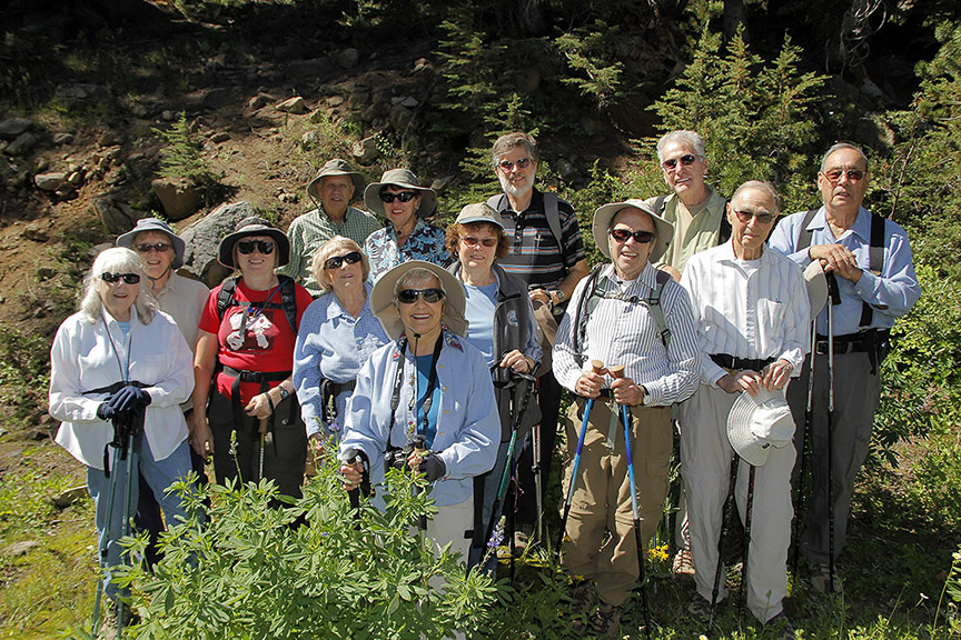
Happy hikers on Aug. 22, 2011, hike up the old route 88 route, between Red Lake
and Carson Pass. Photo by Jay Aldrich.
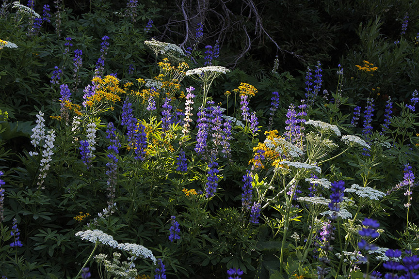
Flowers along the Aug. 22, 2011, hike up the old route 88 route, between Red Lake
and Carson Pass. Photo by Jay Aldrich.
Here's a link to
http://www.aboutlaketahoe.com/hiking.htm which lists links
to a few
hikes that are available in the Lake Tahoe area.
More hikes at http://www.communitywalk.com/user/view/4395
Send me your comments from this
page, or send your comments directly to DCBugli@aol.com.
|