|
Local Links
David Bugli - Home Page
External Links
Carson
Valley Trails Association
Carson
City Weather Forecast

Scan this QR code to access
this page from your smart phone.
|
Hikes
This is the schedule for the Monday hikes, as presented to me in e-mails by
Terri Sutor. I will try to update the list as soon as possible. I
occasionally add links of my own to various websites with more information
on hikes.
Happy Hiking. -David Bugli 6/23/13
- Leader: Terri Sutor 775-267-5366
- Assistants:
- (assistants as listed per hike)
List of hike dates, hike areas, hike leaders, meeting locations, and meeting times
2013 Hikes
- Mon., Jan. 7, 2013 - Up to the cross near Terri's place
Per Terri's 1/6/13 message: "Ed and I are going to
attempt a walk up to the 'cross' tomorrow. If you'd like to join us
meet here at 11 A.M."
Per Terri's 1/7/13 post-hike message: "Seven of
us showed up this morning for a delightful trek up to the cross from our
house. Weather was very comfortable by 11 A.M. and enjoyed by all.
Too bad you missed it!"
- Mon., Jan. 14, 2013 - River Fork Ranch trail
Per Terri's 1/13/13 message: "Supposed to be pretty
cold tomorrow but I'd like to try the River Fork Ranch trail which I spoke of
last week. Meet at 11 A.M. (should be fairly warm by then) at the Nature
Conservancy Building on Genoa Lane. This is about a mile before the town of Genoa.
There is a large sign there on the left which goes into the parking
lot and says River Fork Ranch Trail. We'll convene there. If it's too
cold we'll just call it quits, ok?"
- Mon., Jan. 21, 2013 - Chickadee Hill on snowshoes or skis
Per Terri's 1/20/13 message: "Tomorrow Sharon
Jarrett would like to lead you to Chickadee Hill up from Tahoe Meadows on
snowshoes or skis. Meet her at the Hwy 50 Park N Ride at 10 A.M. to carpool
to the trailhead. Any questions, give her a call."
- Mon., Jan. 28, 2013 -
Per Terri's 1/20/13 message: "On the 28th, Sue
Konkol will take you on the Bentley/Kirman Trail. Meet her at the trailhead
kiosk at 10 A.M. (For those of you who haven't been there before, the
trailhead is on the left about 1/2 mile on Heybourne north of
Stephanie Lane.) Sue can be reached [by phone] in case there is any
question about the weather etc."
- Mon., Feb. 4, 2013 - Dog sled trail at Hope Valley - snowshoes or skis
Per Terri's 2/2/13 message: "On Monday I'd like to
try another snow day. (Sharon only had 2 of you join her at Tahoe Meadows.)
This time we'll drive up to Hope Valley and take off from there on the dog
sled trail with either our snowshoes or skis. Meet at Ironwood at 10 A.M.
for chance of carpooling. Should be back there by 3 P.M. at the latest.
Weather and highway should be very good for our travel."
- Mon., Feb. 11, 2013 - power line road near Terri's
Per Terri's 2/9/13 message: "The weather is supposed
to be rather cold yet on Monday morning, but I'd like to try to get out
anyway. How about meeting at 1 P.M. here at our house for a 3.5 trek up
to the power line road, over to the power station on Stephanie and back via
another street???? If it's a go for you, see ya then."
- Mon., Feb. 18, 2013 - Johnson Lane Wash
Per Terri's 2/15 message: "Looks like Monday should
be a good weather day, so here's what is planned. Jane
Miller and Carol Lark would like to repeat the Johnson Lane Wash hike which we
did some time ago. Meet at 11 A.M. at the end of Johnson Lane where the paved
road becomes dirt. From there they will walk in towards the south (right) for
about an hour and a half, have lunch, and return the same way out.
This is close, comfortable....no elevation...and has great rocks for you
rockhounds."
Per Terri's 2/17 message: "Meet at the end of Johnson
Lane @ 11 AM. Will hike for an hour and a half, have lunch,
and return the same way. The trail is easy with no elevation. Leaders are Jane Miller and
Carol Lark."
- Mon., Feb. 25, 2013 - Bently/Kirman Trail
Per Terri's 2/23 message: "I'm going to assume that
our weather will stay dry so that we can do the Bently/Kirman Trail on Monday.
Ed and I did the short loop yesterday (2.5 miles) and conditions were very good.
Driving in to the kiosk parking was excellent. So....let's meet at 10 A.M. at
the end of the parking lot and plan to do the entire 5 mile trek. For those
of you who don't know, the trailhead can be reached on Heybourne Rd. about
a 1/2 mile from Stephanie in the Johnson Lane area. It's poorly signed,
unfortunately, but once you have passed the last brown house on the left,
look for a little white sign on a post at a driveway leading down to the start
of the trail. (Somebody with the CVTA needs to get better signage done.)"
- Mon., March 4, 2013 - paved roads in the Saratoga Springs community
Per Terri's 3/3 message: "Sandy & Clar Byers will
take the lead for tomorrow's outing...On Monday we will start at 10:00 am
and walk for about 1-1/2 hr -- then have a little snack/lunch at the park
at 11:30....then walk for another hour or so (an easy hike, all paved paths).
Meet at [Sandy's] address: 1282 La Sierra Court. (Is located off Hot Springs Road in
the Saratoga Springs community.)"
- Mon., March 11, 2013 - Voltaire Canyon
Per Terri's 3/9 message: "Monday looks like a good
day weather-wise, so I'd like to explore Voltaire Canyon again which is on the
west side of Carson City. This time, however, after a short walk up the
canyon we'll turn left and march up to the sawtooth ridge which separates it
from Hwy 50. Would like to hike along there or as far as it goes, then go
back down to the canyon road for our walk back. Should probably be about 3 miles.
Meet at the end of Clearview St. where the road is blocked from going into
Volaire Canyon. (Turn left off Carson Street.) How about 10 A.M.????"
- Mon., March 18, 2013 - Prison Hill in Carson City
Per Terri's 3/16 message: "On Monday I'd like to lead
you on a trail around Prison Hill in Carson City. We'll meet at the trailhead
at the east end of Koontz Street, near the big water tank at 10 A.M.
Distance is about 4 miles with very little uphill except at the beginning.
No dogs. Should be back at trailhead by 2 P.M. at the latest. Views
of Carson City are great!"
- Mon., March 25, 2013 - Fay-Luther/Jobs Peak Ranch Trail System
Jane Miller's 3/21 message: "Next Monday we will
meet behind Ironwood at 10:00 am. We will caravan to the trailhead and hike
till about 1:00 or 1:30 pm then head back to Ironwood or wherever we each
disappear to on Monday afternoons (ice cream?). The following address will
give you a full size, printable map of the trail system. I have a route in
mind that will take us over most all of each of the trails except the Job's
Peak trail. Should be a good day. Until March 30th, dogs must be leashed
for winter deer habitat protection.
Address for map: http://carsonvalleytrails.org/docs/FayLuther/FL_Panel_MapSMALL.pdf
Fay-Luther/Jobs Peak Ranch Trail System:
- This trail system connects the Fay-Luther and Jobs Peak Ranch Trailheads
which are 3.5 miles apart. There is a total of about 9 miles of loop and
connector trails to choose from. The Interpretive Loop provides interpretive
signs about the area. There is no trail access to Jobs Peak. Please stay on
designated trails only and respect neighboring private property.
- Bikes and Equestrians: All trails are open to mountain bikes and
equestrians except for part of the Fay-Luther/Jobs Peak Ranch Trail between
Jobs Peak Ranch Trailhead and the Valley View Loop. This section of trail
has loose soils, cable steps and modest terrain challenges. Most of this
section is also within a Douglas County trail easement on private property
which allows hikers only. Mountain biking is difficult on many of these
trails because of sandy, loose soils. Horse trailer parking is present at
the Fay-Luther Trailhead only.
- Dogs: Dogs are allowed everywhere but must be leashed year-round on
the first 1.5 miles from the Jobs Peak Ranch Trailhead because this portion
of trail is within a Douglas County trail easement on private property. Dogs
must also be leased October 15 through March 30 everywhere else to protect
foraging deer during the stressful winter season. There are a high volume of
trail users with dogs on this trail system; please courteously pick up after
your dog by using the provided dog waste bags at the trailheads.
- Environment: The trails are fairly gentle throughout the area. The first
half mile from the Fay-Luther Trailhead and the first mile from the Jobs Peak
Ranch Trailhead have limited shade, travelling through thick areas of big sagebrush, rabbitbrush and bitterbrush. The rest of the trail system is mostly an open Jeffrey pine forest with a mix of singleleaf pinyon, curlleaf mountain mahogany, white alder, aspen, willow and black cottonwood. There are very nice views of the Carson Range, Pine Nut Range and Carson Valley throughout the trail system.
- Directions: From the intersection of Hwy 395 and Hwy 88 in Minden,
drive south on Hwy 88 for 6.5 miles. Turn right on Fairview Lane and drive 1.7
miles (Fairview Lane becomes Foothill Road). The signed Fay-Luther Trailhead is
on the west side of the road with the Jobs Peak Ranch Trailhead 2 miles further.
If you are coming from the base of Kingsbury Grade at the 4-way stop with
Foothill Road, go south on Foothill Road for 2.5 miles to the signed Jobs Peak Ranch
Trailhead on the west side of the road. The Fay-Luther Trailhead is 2 miles further.
- Mon., April 1, 2013 - Old V&T Railroad route
Per Terri's 3/23 message: "I'll still be out of town
on the 1st of April...no fooling...so
Helen and Rudy Moreno will lead you that day. They'd like to do the old V&T
Railroad in Carson City. Meet at 10 A.M. at Gold's Gym, formerly K-Mart, on
College Parkway. They will meet you there and lead to the trailhead....Hike
is about 3 miles, if you go up over the top and down."
- Mon., April 8, 2013 - CANCELLED - Jack's Valley Hill
Per Terri's 4/7 message: "Since snow is reported for
tomorrow morning how about an afternoon hike???????? Let's meet at the Target
parking lot on Jack's Valley Road at 1 P.M. and I'll lead you a short
distance away to the trailhead I have in mind to do some of the Jack's Valley
Hills. Should be about a 3 mile trek with just one uphill. If a blizzard
exists at 1 P.M., of course we'll forget the whole idea. However the weather
report calls for a nice sunny afternoon."
Per Terri's 4/8 message: "Even though the snow has
stopped and the sun is out, it's still too darn cold
out there for hiking. So, hope you won't be too disappointed in hearing that
I've cancelled the event. Let's hope next Monday is better."
- Mon., April 15, 2013 - Jack's Valley Hill
Per Terri's 4/14 message: "For tomorrow hike, let's
try doing the Jack's Valley Hill again. Meet at 10 A.M. at
the Target parking lot on Jack's Valley Road. Rain is predicted but not until
later in the evening. Hopefully we'll be ok."
- Mon., April 22, 2013 - "C" Hill and the Flag in North
Carson City
Per Terri's 4/20 message: "For our next outing, I'd like
to try to attack "C" Hill and the Flag in North
Carson City from Kings Canyon Road instead of the usual road from the RR Museum.
Meet at the Target parking lot on Jack's Valley Road at 9:00 A.M. (Yes it's
time we go back to that hour.) If you are north of that location, then consider
meeting us at the corner of Kings Canyon and Ormsby around 9:15 A.M. From there
I'll lead you up the Canyon for a short ride to our starting point. Perhaps
we'll come across some of the sheep which were place in the area recently."
- Mon., April 29, 2013 - Discovery Trail from Adams Ranch Trailhead.
Leader: Jane Miller 775-392-0456. Meet at "Ironwood Park" at 9:00 a.m.
Per Terri, on 4/27: "Jane Miller will take the lead
again on Monday to do the fairly new Discovery Trail from the Adams
Ranch Trailhead for about 4 to 5 miles total. Meet at the Mormon Station on
Genoa Lane at 9 A.M. From there you will caravan to the trailhead which
is up at the large water tank on Adams Ranch Road. (Folks coming from Carson
City can meet around 9:15 at the trailhead if you desire.) ....She plans to
walk to the 4-way junction coming up from Sierra Canyon, then turn around
back to the beginning trailhead at the water tank."
- Mon., May 6, 2013 - Trail along new freeway in Carson City. Leaders: Helen &
Rudy Moreno 775-882-6480. Meet at Big 5.
Per Terri, on 5/4: "This Monday Helen & Rudy Moreno
will lead us on an easy paved trail along the new freeway in Carson City.
Signs are along the way which will illustrate the
landscaping and enlighten us about the many metal sculptures which can be found
along the banks of the freeway. The route is referred to as the "Grow Tour".
The trek will be about 4 miles. Bring water and a snack. Dogs are ok on a
leash. Meet at Gold's Gym on College Parkway in Carson City at 9 A.M.
We will caravan a short distance from there to our starting point. Any
questions, call the Moreno's."
- Mon., May 13, 2013 - Ormsby Loop. Leaders: Helen & Rudy Moreno 775-267-5366.
Meet at 816 Terrace St., Carson City.
Per Terri, on 5/11: "This Monday Helen & Rudy Moreno
will lead us on the Ormsby Trail in Carson City. From their home on 816
Terrace Street the adventure will follow some of the lower trail on Flag Hill
and then down through some of the community streets. It's a neat way to
see some of the city that you may never have known existed. Meet at their
home at 9 A.M. Probably will walk about 5 miles."
- Mon., May 20, 2013 - Job's Peak Ranch Trail to Fay Luther T/H. Meet at "Ironwood Park" at 9:00 a.m.
Per Terri, on 5/18: "Just a note to remind you that
Monday's hike will be from Job's Peak Ranch Trailhead to Fay Luther, a
distance of 4 miles. Either meet at Ironwood at 9 A.M. or the starting
point at 9:30 A.M."
- Mon., May 27, 2013 - Trail to Carson River from Indian Creek Reservoir.
Leader: Sharon Jarrett 775-782-2834. Meet at "Ironwood Park" at 9:00 a.m.
Per Terri, on 5/18: "...on Monday, the 27th, Sharon
Jarrett will lead you down to the Carson River from a parking area
near Indian Creek Reservoir. Meet at Ironwood at 9 A.M. Furthermore,
I will not be sending out any more weekly reminders unless there is a
change in the schedule, so keep yours handy!"
- Mon., June 3, 2013 - Slaughterhouse Canyon & Skunk Harbor. Meet at Hwy 50 Park 'n Ride.
- Mon., June 10, 2013 - Cascade Falls/Granite Lake. Meet at "Ironwood Park" at 9:00 a.m.
- Mon., June 17, 2013 - Daggett Pass to Brautovitch Park trailhead. Meet at "Ironwood Park" at 9:00 a.m.
(George Brautovich Park is located on Andria Way, just off the Kingsbury Grade.)
- Mon., June 24, 2013 - Stagecoach to Van Sickle Park. Meet at "Ironwood Park" at 9:00 a.m.
Per Terri, on 6/24: "Consider today's outing CANCELLED!
The weather just looks too unsettling and chance of rain is too high. I'd
like to try the same plan on Wednesday. Any takers? If so meet me at
Ironwood at 9 A.M. or Stagecoach at 9:30. that morning. The Menningers
are willing to host afterwards."
- Wed., June 26, 2013 - RESCHEDULED HIKE: Stagecoach to Van
Sickle Park. Meet at "Ironwood Park" at 9:00 a.m. or Stagecoach [Heavenly] at 9:30.
The Menningers are willing to host us afterwards.
- Mon., July 1, 2013 - Big Meadows trailhead to South Upper Truckee Road. Meet at "Ironwood
Park" at 8:00 a.m.
Per Terri, on 6/30: "Tomorrow we will meet at 8 A.M.
at Ironwood instead of our usual time of 9 A.M. I'd like to beat the
heat with an earlier start. We will drive to the Big Meadows Trailhead,
hike the TRT [Tahoe Rim Trail] for 2 miles then turn north for 3 more miles
on the Christmas Valley Trail to Upper Truckee Road. Make sure you have
mosquito and biting fly repellent. We were up there today and at times the
critters were nasty. The trail is a gradual uphill for the first 2 miles then
levels off for the last 3."
- Mon., July 8, 2013 - Top of the Tram to Monument Peak. Leaders: George & Pat
Menninger 775-588-7285. Meet at "Ironwood Park" at 9:00 a.m.
Per Terri, on 7/2: "I'm leaving town tomorrow and
won't be back until the 13th. In the meantime, on Monday, George and
Pat Menninger will be leading you to the top at Heavenly and riding the tram
back down...free. (Perhaps some of you might even like to do Monument Peak
while in the vicinity?) Dave Bugli will gather you together at Ironwood
at 9 A.M. and get you to the Swim Center on the corner of Tramway & Olympia
where you will meet up with Pat & George. Trip uphill should be about
4 miles..says George...."
|
Per Terri, on 7/2: "As for the remainder of July outings,
I'd like to begin our starting time back an hour to 8 A.M. We found that
time a great advantage yesterday when it really started to heat up in
the afternoon. So mark your calendars for the new time.
(We'll discuss the possibilities for August later.)"
|
- Mon., July 15, 2013 - Red Lake/Frog Lake/ Devil's Ladder. Meet at "Ironwood Park"
at 8:00 a.m.
Per Terri, on 7/14: "Just a reminder that we will begin tomorrow's outing with a
meeting at Ironwood Park at 8 A.M.
We will travel and park at Red Lake, hike up along the lake for a mile or so
to view the pictographs made by the travelers on the Emigrant Trail around
the 1860's. From there we will climb about 1/2 mile to Frog Lake where we
will meet the PCT [Pacific Crest Trail] and head south to a turnoff which will
follow an old road back down to our vehicles at Red Lake. Total outing should
be between 5 to 6 miles. I've never done this entire loop as one trip yet but
Mary Erba has and will aid us along the route. Come join the adventure.
See ya at 8! Tahoe folks could meet us at Red Lake around 8:45."
- Mon., July 22, 2013 - Woods Lake/Winnemucca Lake/ Round Lake Loop. Meet at "Ironwood
Park" at 8:00 a.m.. Here is a link to a Reno Gazette-Journal
video about Winnemucca Lake:
http://www.rgj.com/videonetwork/2577564848001/RGJ-explores-breathtaking-hike-to-Winnemucca-Lake. The
accompanying article is posted at
http://www.rgj.com/article/20130801/LIV08/308010022?source=nletter-top5. This
article may not be available to people who don't subscribe to the Reno paper.
- Mon., July 29, 2013 - Schneider Cow Camp to Showers Lake. Meet at "Ironwood Park"
at 8:00 a.m.
|
Terri announced on 7/22/13 that the meeting time for hikes in August
would be changed from 9:00 a.m. to 8:00 a.m. The meeting place for all the
August hikes is "Ironwood Park."
|
- Mon., August 5, 2013 - Cathedral Lake. Meet at "Ironwood Park" at 8:00 a.m.
- Mon., August 12, 2013 - North Kingsbury T/H to Boulder on Tahoe Rim Trail. Meet at
"Ironwood Park" at 8:00 a.m.
- Mon., August 19, 2013 - Lam Watch Nature Trail /Round Hill. Meet at "Ironwood Park"
at 8:00 a.m.
- Mon., August 26, 2013 - Ebbett's Pass to Nobel Lake on PCT (7.4 mi.). Meet at
"Ironwood Park" at 8:00 a.m.
- Mon., Sept. 2, 2013 - Labor Day, Leader - TBD?
- Mon., Sept. 9, 2013 - Spooner Lake Hike & Pot Luck at 10 A.M. Meet at Hwy 50 Park 'n Ride.
- Mon., Sept. 16, 2013 - Green Creek to Green Lake. Meet at "Ironwood Park" at
9:00 a.m.
- Mon., Sept. 23, 2013 - Daggett Summit Loop on TRT. Meet at "Ironwood Park" at 9:00 a.m.
- Mon., Sept. 30, 2013 - Mt. Rose Trail to Waterfall Loop. Meet at Hwy 50 Park 'n Ride.
- Mon., Oct. 7, 2013 - Granite Lake from Lower Blue Lake. Meet at "Ironwood Park" at 9:00 a.m.
- Mon., Oct. 14, 2013 - Sierra Canyon to Genoa Canyon (7.5 mi.). Meet at Mormon Park in Genoa at 9:00 a.m.(?)
- Mon., Oct. 21, 2013 - Leader ?
- Mon., Oct. 28, 2013 - Emma Lake in Hoover Wilderness. Meet at "Ironwood Park" at 9:00 a.m.
- Remainder of year will be determined upon the weather.
Westwood Park (informally known as "Ironwood Park") is on the corner of
Ironwood Drive and Pinewood Drive in Minden.
View Larger Map
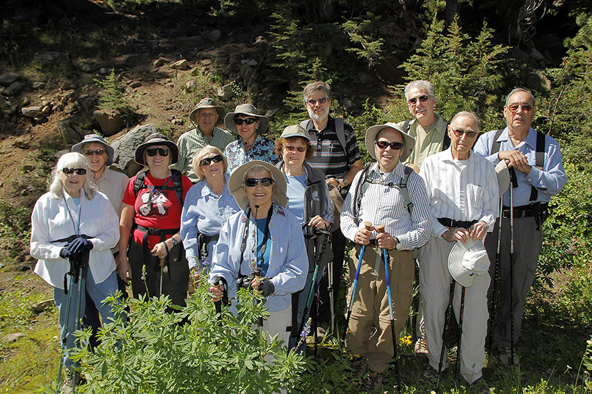
Happy hikers on Aug. 22, 2011, hike up the old route 88 route, between Red Lake
and Carson Pass. Photo by Jay Aldrich.
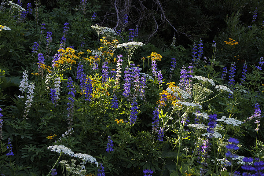
Flowers along the Aug. 22, 2011, hike up the old route 88 route, between Red Lake
and Carson Pass. Photo by Jay Aldrich.
(Click here to see a list of the 2011 hikes.)
(Click here to see a list of the 2012 hikes.)
Here's a link to
http://www.aboutlaketahoe.com/hiking.htm which lists links
to a few
hikes that are available in the Lake Tahoe area.
Muscle Powered Carson City promotes biking and walking trails in Carson
City. Check there for Tuesday walks that they and/or Carson City Parks and Recreation
Department sponsor or feature. Just check the calendar page.
More hikes at http://www.communitywalk.com/user/view/4395
Send me your comments from this
page, or send your comments directly to DCBugli@aol.com.
|